|

Back
to What's New
October 2004
Black Sea Cruise for
BP Exploration Operating Company Ltd.
TDI-Brooks Int’l Inc. in September
2004 conducted for BP Exploration Operating COMPANY Ltd a
geochemical and geotechnical coring, environmental sampling,
and metocean study. The study was carried out in their ART/TPO-BP/3534
Block, offshore Turkey. The block lies in the far eastern
part of the Turkish Black Sea adjacent to the border with
Georgia. The centre of the Block is approximately 40-km offshore
and approximately 130-km east-northeast of the port of Trabzon.
The cruise was mobilized and demobilized out of Trabzon.
Environmental sampling was carried
out consistent with the HSE and baseline monitoring requirements
for Turkish EIA purposes. This component entailed seabed
sediment box core sampling, ecological and water testing/sampling
and plankton studies. The geochemical coring component was
undertaken to investigate seepage over features identified
from 3-D seismic data surveys in the block. The geotechnical
and sedimentological cores in water depths between 1,100 and
1,750 meters were acquired for engineering purposes. The seabed
morphology in the survey area is complex with broad and deep
(i.e., up to 250-300 meters) canyons crossing the area. Vertical
Acoustic Doppler Current Profiler (ADCP) profiles were undertaken
to measure current profiles in the study area.

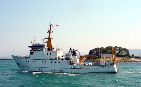
Picture 1 - The R/V PIRI REIS
TDI-Brooks conducted the survey
using the Turkish research vessel, the R/V PIRI REIS (Picture
1), mobilized out of Izmir. The R/V PIRI REIS is the primary
multi-use oceanographic research vessel in Turkey. It is a
36-meter vessel, built in 1978 in Germany and has current
Germanisher Lloyd classifications and inspections. TDI-Brooks
worked with BP to achieve stringent HSE standards and implementation
of BP’s Golden Rules using the vessel. The HSE component
consisted of significant vessel upgrades to its safety equipment
and procedures, development of JSA’s for all activities and
training of the ship’s crew. A three-day Pre-Start Meeting
was held immediately prior to the start of the cruise focusing
on safety, health and environmental issues.
|

|
|
|
|
|
Picture Plate 2 - Gravity Coring Operations
The study was conducted during two consecutive
cruise legs mobilized from Trabzon. On Leg I (six days)
the coring and metocean components were conducted. The
coring was conducted with a 4-meter, 300-kilo coring rig
using PVC liner (Picture 2). Cores were “navigated” to
coring targets with a Kongsberg-Simrad HP-410 USBL and MST-342
beacons attached to the corer. The USBL transducer was
mounted on a side pole-mount. GeoNav software was used
in conjunction with C-Nav differential signals and the USBL
positioning hardware to provide precision DGPS positioning
of all cores. A 300 KHz RD Instruments ADCP was deployed
on the ship’s hydrowinch to obtain vertical current meter
profiles from the surface to the seafloor (Picture 3).


Picture Plate 3 - ADCP Deployment
The environmental sampling component of the program was
conducted on Leg II (five days). Gardline Environmental under
contract from ENRS/RSK conducted sampling of the water column
and benthic environments at anticipated drill sites to characterize
the water and sediment chemistry (Picture Plate 4). Extensive
box core sampling was also conducted around the proposed drill
sites in an attempt to characterize the macro-infauna, though
onboard indications were that macro-infauna were completely
absent at depths sampled due to the high concentrations of
H2S in the sediment/water interface and the lack of dissolved
oxygen below the thermocline. Plankton studies (phyto, zooplankton,
and ichthyoplankton) were conducted by professors from the
Black Sea Institute.
  
Picture Plate 4 - Plankton , cox coring
and water column sampling operations
Participants in the TDI-Brooks
team on this project were AOA Geophysics and Texas A&M
University who assisted with the navigated cores and ADCP
measurements respectively.
|
